Property Record
8489 Hilltop Dr, Ooltewah, TN 37363

NEARBY LISTINGS FOR SALE OR LEASE
Property Detail
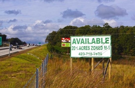
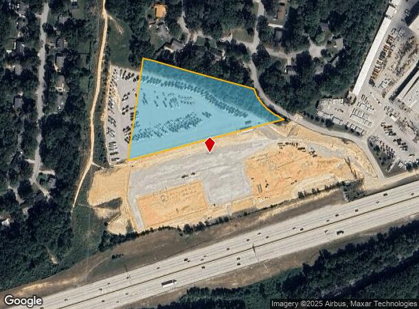
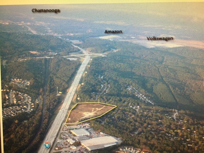
8489 Hilltop Dr
131-044
COUNTRY VILLAGE DR
Commercialacreage
Hamilton
X
Tennessee
47065C0379G
4.40 AC
2024
Outlying Chattanooga
2024
Chattanooga
011447
Chattanooga, TN-GA
DEMOGRAPHICS near 8489 Hilltop Dr
1 Mile
3 Mile
5 Mile
2024 Total Population
2,856
23,582
69,681
2029 Population
2,995
25,080
74,123
Pop Growth 2024-2029
+ 4.87%
+ 6.35%
+ 6.37%
Average Age
40
41
41
2024 Total Households
1,109
8,619
26,167
HH Growth 2024-2029
+ 5.05%
+ 6.52%
+ 6.56%
Median Household Inc
$91,154
$79,517
$81,509
Avg Household Size
2.50
2.50
2.50
2024 Avg HH Vehicles
2.00
2.00
2.00
Median Home Value
$254,680
$268,375
$268,385
Median Year Built
1997
1999
1994
Nearby Places
Map Layers
Map Styles
 Street
 Aerial
- Restaurants
- Banks
- Shops
- Fitness
- Groceries
PUBLIC TRANSPORTATION
AIRPORT
Lovell Field
DRIVE
WALK
Distance
Lovell Field
23 min
12.1 mi
Freight Ports
Georgia Ports - Savannah
DRIVE
WALK
Distance
Georgia Ports - Savannah
415 min
369.0 mi
SALE & LEASE HISTORY
LISTING DATE
SALE/LEASE

Oct 19, 2016
For Sale
Nearby Properties
Address
Land Use
TOTAL SIZE
Lot Size
Zoning
Address
Land Use
TOTAL SIZE
Lot Size
Zoning
2,025,141 SF
1,096 AC
M1
Address
Land Use
TOTAL SIZE
Lot Size
Zoning
0.53 AC
M1
Address
Land Use
TOTAL SIZE
Lot Size
Zoning
213,416 SF
56.75 AC
Address
Land Use
TOTAL SIZE
Lot Size
Zoning
333,801 SF
15.44 AC
C2
Address
Land Use
TOTAL SIZE
Lot Size
Zoning
337,464 SF
21.82 AC
A
Address
Land Use
TOTAL SIZE
Lot Size
Zoning
287,820 SF
13.33 AC
R3
Address
Land Use
TOTAL SIZE
Lot Size
Zoning
319,975 SF
20.51 AC
Address
Land Use
TOTAL SIZE
Lot Size
Zoning
102,382 SF
29.80 AC
M2
Address
Land Use
TOTAL SIZE
Lot Size
Zoning
60,561 SF
M2
Address
Land Use
TOTAL SIZE
Lot Size
Zoning
237,764 SF
60.56 AC
Address
Land Use
TOTAL SIZE
Lot Size
Zoning
276,677 SF
20.13 AC
R4
Address
Land Use
TOTAL SIZE
Lot Size
Zoning
250,284 SF
16.45 AC
Address
Land Use
TOTAL SIZE
Lot Size
Zoning
91,460 SF
Address
Land Use
TOTAL SIZE
Lot Size
Zoning
223,968 SF
16.33 AC
Address
Land Use
TOTAL SIZE
Lot Size
Zoning
95,048 SF
14 AC
A
Address
Land Use
TOTAL SIZE
Lot Size
Zoning
353,653 SF
25.90 AC
M1
Address
Land Use
TOTAL SIZE
Lot Size
Zoning
156,170 SF
6.60 AC
M1
Address
Land Use
TOTAL SIZE
Lot Size
Zoning
216,335 SF
27.21 AC
C2
Address
Land Use
TOTAL SIZE
Lot Size
Zoning
181,036 SF
6.27 AC
R3
Address
Land Use
TOTAL SIZE
Lot Size
Zoning
79,101 SF
8.53 AC
C2
Address
Land Use
TOTAL SIZE
Lot Size
Zoning
48,720 SF
14.12 AC
Address
Land Use
TOTAL SIZE
Lot Size
Zoning
110,437 SF
13.89 AC
Address
Land Use
TOTAL SIZE
Lot Size
Zoning
97,487 SF
3.65 AC
C2
Address
Land Use
TOTAL SIZE
Lot Size
Zoning
81,723 SF
12.27 AC
C2
Address
Land Use
TOTAL SIZE
Lot Size
Zoning
64.53 AC
Address
Land Use
TOTAL SIZE
Lot Size
Zoning
89,217 SF
11.85 AC
Address
Land Use
TOTAL SIZE
Lot Size
Zoning
54,464 SF
2.20 AC
Address
Land Use
TOTAL SIZE
Lot Size
Zoning
59,594 SF
7.61 AC
A
Address
Land Use
TOTAL SIZE
Lot Size
Zoning
62,297 SF
426 AC
IN
Address
Land Use
TOTAL SIZE
Lot Size
Zoning
55,372 SF
5.36 AC
C4
The World's #1 Commercial Real Estate Marketplace
Connect with us
© 2025 CoStar Group
The information above has been obtained from sources believed reliable. While we do not doubt its accuracy we have not verified it and make no guarantee, warranty or representation about it. It is your responsibility to independently confirm its accuracy and completeness. Any projections, opinions, assumptions, or estimates used are for example only and do not represent the current or future performance of the property. The value of this transaction to you depends on tax and other factors which should be evaluated by your tax, financial, and legal advisors. You and your advisors should conduct a careful, independent investigation of the property to determine to your satisfaction the suitability of the property for your needs.